|
This article is taken from "Gayhurst: A Study of the Park and Gardens" by Janet Jack and is reproduced here with her kind permission.
GAYHURST
|
||||||||||||||||||||||||||||||||||||||||||||||||||||||||||||||||||||||||||||||||||||||||||||||||||||||||||||||||||||||||||||||||||||||||||||||||||||||||
|
THE HISTORY OF THE GAYHURST ESTATE AND LANDSCAPE |
||||||||||||||||||||||||||||||||||||||||||||||||||||||||||||||||||||||||||||||||||||||||||||||||||||||||||||||||||||||||||||||||||||||||||||||||||||||||
|
Size and Shape At the time of the Domesday survey Gayhurst had about 960 acres of ploughed land with enough woodland to support 80 pigs. The entry reads as follows: The Bishop of Lisieux holds Gayhurst from the Bishop of Bayeux, and Robert of Noyers from him. It answers for 5 hides. Land for 4 ploughs; in lordship 2 ploughs. 10 villagers have 2 ploughs.2 slaves; 1 mill at 13s 4d; meadow for 4 ploughs; woodland, 80 pigs. In total, the value is and was 100s; before 1066 £8. Seric, Earl Leofwin's man, held this manor; he could sell. Using the "rough-and-ready rate of 120 acres to the plough" and the pig-ratio interpolated from Oliver Rackham's The Last Forest as a guide, there would have been about 960 acres for the plough and a further 200 acres of woodland to support the 80 pigs, giving a total land holding in the region of 1160 acres. From “Victoria County History” we see that: ...in 1229, Aumary de Mowers obtained a licence to impark his inclosed wood at Gayhurst with immunity from forest rights. This immunity was recognised as a manorial liberty in 1279. Another liberty mentioned at this date was that of free fishery. There was a mill on the manor in 1086, and references to a water-mill are found from 1279 to the 17th century. In 1265, with the marriage of Isabel de Stoke Goldington to William de Nowers. the parishes of Stoke Goldington and Gayhurst were combined. The Domesday records show Stoke Goldington in two ownerships of 370 acres and 1,460 acres, using Oliver Rackham's method to approximate the area of the woodland. So if Isabel was heiress to both these estates she would have brought with her an additional 1,830 acres, bringing the total close to 3,000 acres. The Christopher Saxton map of Buckinghamshire dated 1574, shows churches at Gayhurst. Stoke Goldington, Lathbury, Moulso and Anslop (Hanslope). There are parks shown at Moulso and Anslop which, as described by Hugh Prince in “Parks in England "...are represented by conventional symbols as preserves for deer enclosed by wooden palings." By the early 17th century the Manors of Gayhurst and Stoke Goldington were said in the “Calender of Deeds”, to comprise ...with their appurtenances and thirty messuages, two mills, three dovecotes, thirty gardens, thirty orchards, a thousand acres of land, four hundred acres of meadow , a thousand acres of pasture, six hundred acres of wood, six hundred acres of furze, one head, and forty shillings worth of rent. This totalled well over 3,600 acres, so the estate had been increasing steadily in size over the years. There is no mention of mills although it is known that At a Court Baron of April 1628 the tenants were ordered to grind their corn at the mill of the lady of the manor; the water-mill and two houses adjoining, then leased to George Backhouse, were in disrepair, and one of the mill-houses had been converted into a cottage by 1654. (Court of Rolls penes Mr. F. Bull). By 1673 the “Calender of Deeds” shows in the will of John Digby that he left an annuity to his wife, Dame Margarett "...to be paid out of my manners, messuages, pastures, lands, meadows, Tenements, and Hereditaments in Gayhurst and Stoke Goldington, Hanslop and Lathbury," and to his daughters Mary Digby and Charlotta Digby divided all my Manners Advowsons, rights of Patronage, Woods, Parkes, Warrens, Lands, Meadows, Pastures, Waters, Mills, Fishings Rights, Privileges, Courts, views of Franke Pledge, Tenementes and Hereditaments in the parishes of Gayhurst, Stoke Goldington, Hanslop and Lathbury.... The estate had increased again with Hanslope to the west and to the south Lathbury on the Great Ouse. Stoke Goldington lay to the north and Gayhurst held the central position. The next account of Gayhurst's size is contained in a description of the estate in 1691/2 in the “Calender of Deeds”. This Indenture 24 Feb. made in the fourth year of the Raigne of our Sovereign Lord and Lady William and Mary by the Grace of God of England and Scotland, France and Ireland....Between Richard Mostyn of Penbedow..." (Who was Charlotte's husband) "...with the moyety of all the buildings, bames, stables, orchards, gardens...yuards, backsides and all other appurtenances unto the same belonging ...in the parishes of Gothurst and Lathbury. ...thirty messuages, 40 cottages, 50 gardens , 50 orchards, 1000 acres of land (arable, as opposed to meadow and pasture) 500 acres of meadow, 1000 acres of pasture, 400 acres of wood, 1000 acres of furse and heath and Common of Pastures with the apertenances. The numbered acreage amounts to 3,900 acres and the adjustments were as follows: Gardens and orchards had each increased by 20 acres Meadow had increased by 100 acres Furze had increased by 400 acres Woodland had decreased by 200 acres So the estate had increased by 300 acres plus 20 gardens and 20 orchards since Mary Digby's day at the beginning of the 17th century. There is a detailed account in the “Calender of Deeds” of the estate on its sale by Sir John Conway and Richard Mostyn, husbands of Mary and Charlotte Digby (both deceased) to George Wrighte in 1704. The ...Mansion or Manor House of Gayhurst alias Gothurst ...all stables, Dovehouses. Barnes. Outhouses, Buildings, Edifices, Yards, Orchards, Gardens, Courts, Backsides, Curtilages. ...All those several messuages or dwelling houses...and all those several closes, or Inclosed Grounds of Land arable, meadow, pasture, wood, woodmound in Gayhurst. [Description by each hereditament] Acreage
Several ponds in Gayhurst alias Gothurst. All that water borne Mill In Gothurst aforesaid in the tenure of Marke Perry and the Mill Holme 3.24 The Meadow ground thereunto adjoining 2 The other parcel of ground to the said Mill adjoining (also in the tenure of Marke Perry) 1.6 a and all those several closes of Grounds inclosed of arable meadow pasture and wood ground with their several...west field, the Millfield, the Hoo Wood,the Hoo Close, the Field Close, Houghton Leyes and the Furzen Close...and all in Stoke Goldington in the tenure of Henry Bird estimated at 229 and all...in Robert Abrahams occupation 100 There follows a series of 16 entries amounting to 626 more acres. The total amounts to 2,048.56 acres and as it is only the Gayhurst Estate, that would account for it being less than the 3900 acres in Gayhurst and Lathbury Estate described in the Indenture of 24th February 1691, made by Richard Mostyn. Perhaps Lathbury had been sold separately. So the estate, which was something over 2,050 acres when the buildings, yards, orchards etc, are added, had come into the Wrighte family who were to make significant changes to the landscape as well as the house. Summary of the acreage of the estate from Domesday to the end of the 17th century 1086 Domesday - approximately 1160 acres 1265 1832 acres in the parish of Stoke Goldington added. 2790 acres Early C17th the manors of Stoke Goldington and Gayhurst. 3600 acres 1673 Stoke Goldington. Gayhurst, Hanslop and Lathbury. No size given 1691/2 The greatest size the estate ever reached. 3900 acres The Wrighte Period. J.J. Sheahan said in “The History and Topography of Buckinghamshire”, that the parish of Gayhurst was enclosed in 1710, "by private agreement amongst the inhabitants, “and it would have been that stage which was shown on a map Thomas Wright observed on his visit to the house in 1885 and recorded in “The Town of Cowper”. He wrote: Besides his additions to the mansion, Wrighte effected great improvements in the park, but in order to a proper understanding of his alterations we must consult a curious old map (date 1711) still hanging at Gayhurst, which represents the estate as it was when he bought it. It is sad that the 1711 plan is missing and we may never have a full understanding, as the next available map, which is by Andrew Bryant and dated 1824, although showing the shape of the park quite well, does not show the estate area and cannot be relied upon for the accuracy of the buildings. It shows the house as a different shape with the wrong orientation and position There are four sets of sales particulars extant, two of which, the 1850 and the 1983 have accompanying plans. There are no plans for the 1881 and 1969 sales. The first shows that Lady Macdonald was thinking of selling Gayhurst in 1850. She did not sell then but the documents give a good picture of what the whole estate of Gayhurst and Stoke Goldington comprised at the time. There is a copy of the plan in the Carrington archives marked up to show farms and tenant farmers. It has been coloured to help identify these farms and to compare them with the 1983 plan which is also divided into farm tenancies. The sales particulars of 1850 state that the estate was 2.475 acres, comprising nine farms. Some are rather fragmented. A number of the names and acreages are the same as they were when George Wrighte first bought the estate in 1704, for example:1704 Acres 1850 Acres
At that time the estate agents considered that if the park were to be improved it should enclose about 600 acres, and a pink line defined this on the plan). It shows the estate bounded by the River Ouse to the north-east, the Hanslope road to the north, the Wolverton road to the south-east, and takes in Gayhurst and Bunsty Woods to the north and Stocking and Hoo Woods to the south-west. Summary of the acreage of the Estate whilst in the hands of the Wrightes and Wyndhams, 1704 - 1881 1704 George Wrighte bought the property 2050 acres 1881 Lady Macdonald (a Wyndham) sold the property to James Carlile. 2475 acres The sale papers of 1881, when Lady Macdonald actually sold the property, and which persuaded James Carlile to buy Gayhurst, describe an estate of 2,475 acres comprising the Manors of Stoke Goldington. Gayhurst, and of the Three Hundreds of Newport, woods full of thriving oak, some handsome sheets of water and some valuable Glebe lands. There is no plan with the sales documents but the 1881 OS 6 inches to the mile shows the parkland. The estate had not altered since 1850. The property stayed with James’ son, Sir Walter Carlile, until he sold to Lord Hesketh in 1931 with an arrangement to remain there as a life tenant. The third set of sales particulars is dated 1969, when the Rev. Martin sold Gayhurst after running Rodbourne College, a boys school, for six years. It was 45.5 acres at the time and comprised "...well timbered Parkland, partly suitable for Playing Fields, with the usual amenities of pleasure gardens, lawns and kitchen garden, and the grounds surrounding a small Church." The sizes were meticulously given as:- Acres Grassland 12.92 Parkland 13.249 New Building 1.461 Mansion and Grounds 13.118 Gardens and Grounds 4.765 which amounts to 45.514 acres. The document continues "...The Kitchen Gardens are walled and extend to just over one acre, and include potting sheds, greenhouses, etc...The Parkland lying to the North and East of the House contains valuable matured trees of a wide variety". According to the “Milton Keynes Pictorial” of 2.5.69 the Rev. Martin had bought the property from two men who planned to convert it into flats and maisonettes. The last of the sale particulars, dated 1983. marks the break-up of the estate. It is now divided into at least six ownerships; a small part only being retained round the house for the use of the residents. When Lord Hesketh put the estate up for sale in 1983. 1,277 acres were put on the market, which included three farms amounting to 915 acres, 350 acres of commercial woodland, 11 acres of lakes and small river areas, including half a mile of valuable frontage on the River Ouse. The valuable shooting and the proximity of the two local hunts mentioned in the sales document, reminds us that Gayhurst, through the ages has been used for hunting, shooting and fishing. It was also indicated that the planning authority would look favourably on proposals to convert the old Bath House into a country house. With the house previously sold to developers there was no longer any reason to keep the estate together. The Bath House was sold separately, and the farmland sold off as an investment Summary of the acreage of the Estate from James Carlile's occupation to the present day 1881 James W Carlile purchased Gayhurst. 2475 acres 1931 Sir Walter Carlile sold property to Lord Hesketh. 2475 acres 1983 Lord Hesketh sold estate. Bath House sold separately. Merchant Venturers buy farms as investment. Miscellaneous areas sold separately. 1277 acres Contemporary Descriptions of the Landscape The walled garden of over an acre to the south of the stable block was thought by the Buckinghamshire Archaeological and Architectural Society, on their annual outing in 1930, to be 16th century because of its gateway which is similar to the two dating from 1520 in the cellar of the house. They reported: "as an example of a 16th century garden with original walls it is very well worth examining..." The Walled Garden
The walled garden is more likely to have been built by the second George Wrighte who restored the Kenelm Digby initialled archway in the house, having found it in an outbuilding. The Archaeological Society also comments on the stone piers which articulate the yew hedges on the northeast side of the house, attributing their nautical ornament to Sir Kenelm Digby: In his earlier days he distinguished himself in the navy, and it is said that the badge which appears... - consisting of three bolt-heads and a ring under a rope-sling - on the bases of the pillars with pierced finials which adorn the garden, is a sign of his right to moor his barge at the Royal Wharf. It does not claim that these were contemporary with Sir Kenelm. They could have been a later addition celebrating the honour. On an earlier visit in 1908 the Archaeological Society had described the pillars: "The stone is remarkably well preserved. The forecourt is flanked by pedestals carrying open obelisks of fine design now connected by clipped yew hedges." Of Sir Kenelm they say he was: "famous, handsome and of great stature.... Whilst some were struck by his universal knowledge, others doubted his veracity, while to Evelyn he was a mountebank." Perhaps he had not co-operated with Evelyn's call to estate owners to plant trees after the devastation of the Commonwealth period.
On their 1930 visit the Archaeological Society make an observation on the garden which is not made elsewhere: Another thing which should be mentioned is that the approach to the house on this side originally had a flagged walk, flanked by a low wall, with strap-work carving. In the time of the Wrightes this was moved to the N.E. front and leads by steps to a lawn, which a sunk-fence separates from the park. There is no reference to the origin of the information and the low wall is not shown on any of the engravings of the front of the house and the lawn but the steps, the low wall and the ha-ha are there and appeared between 1850 and 1881. Victoria County History also reports on the pillars. Sir Kenelm, being responsible for the stone posts in the yew hedge. Sir Kenelm was a commissioner of the navy at the beginning of the reign of Charles I and in 1628 commanded a small squadron under that monarch with considerable address; his connection with the navy evidently accounts for the anchors which are carved on the stone posts above referred to and on the plinths of columns before the main entrance. Sir Kenelm is also said to have been responsible for importing "...from the South of France, for the use of his wife Lady Venetia, who was consumptive, the large edible snail called Helix pomatia which still abounds in the woods at Gayhurst." There was, in 1914 when the VCH report was written, a sundial bearing the date 1670 and the motto 'Nul que une' which is no longer there. Lady Carlile, who lived at Gayhurst until 1950 and in the village until 1991, remembers the sundial and says it disappeared in the days of the second developer who converted the house into flats. The poet William Cowper (1731-1801) lived in Olney a small town, about five miles away from Gayhurst. He wrote copiously, recording among other things, his frequent visits to Gayhurst. On the third of December 1778 he wrote to Revd. William Unwin: I made Weight's Gardener a Present of 50 sorts of Stove Plant Seeds, (3) in return he has presented me with Six Fruiting Pines, which I have put into a Bark Bed, (4) where they may thrive at present as well as I could wish. If they produce good Fruit, you will stand some little Chance to partake of them. But you must not expect Giants, for being transplanted in December will diminish their Size. He has promised to supply me with still more plants in October, which is the proper Season for Moving them, and with a Reinforcement every Succeeding year -purchased for less than three Guineas. - Tis thus we Great Gardeners establish a beneficial Intercourse with each other, and furnish ourselves with valuable things that therefore, cost us nothing. The notes are explained as follows: Note 3. 'Such tender exotics from the hot parts of the world, that require the aid of a Stove to preserve them in this country*. Note 4. 'Hot-beds, formed of tanner's-bark, and such that support the most uniform and durable temperature of heat, and the best calculated hot-bed yet known, for the cultivation of all sorts of tender exotics from the warm parts of America, Asia and Africa, that require the continual aid of artificial heat to maintain them in this country. The Gayhurst glasshouses, and most probably the site of the stove house of 1778, are shown on the 1881 O.S. Map on the north wall of the walled garden facing south. To the south-west of the walled garden and the orchard is a belt of horse chestnuts providing additional shelter from the strong south-west winds racing across open fields. In a letter to the Revd. William Unwin the following year, dated 21st September 1779, Cowper wrote of another visit to Gayhurst. Your mother and I, last Week made a Trip in a Post Chaise to Gayhurst, the seat of Mr. Wrighte, about 4 miles off. He understood that I did not much affect Strange Faces, and sent over his Servant on purpose to inform me that he was gadding into Leicestershire, and that if I chose to see the Gardens I might gratify myself without Danger of seeing the Proprietor. I accepted the Invitation & was delighted with all I saw there; the Situation is happy, the gardens and Orange Trees the most captivating Creatures of the kind I ever saw. The orange trees were probably in the sheltered shrub garden to the west of the house, and might also have been on the axis on the north-west side in amongst the shrub beds The Gayhurst pineapples he acquired inspired him to write a five verse poem titled 'The Pine Apple and the Bee1 published in 1782. He sent it in a letter to Joseph Hill the gardener at Gayhurst in October 1779. The first and last verses read as follows: The Pine Apples in triple Row Were basking hot & all in Blow, A Bee of most discerning Taste Perceived the Fragrance as he pass'd, On Eager Wing the Spoiler came and searched for Crannies in the Frame, Pushed his Attempt on every Side, To every Pane his Trunk applied, Exposed to view but not to Touch, That Sight our foolish Heart inflames, We Long for Pine Apples in Frames, With Hopeless Wish one Looks & Lingers One breaks the Glass & Buts his Fingers But they whom Truth & Wisdom lead, Can gather Honey from a Weed. He finished the letter by saying "My affectionate Respects attend Mrs Hill, She has put Mr Wright to the Expense of Building a New Hot house. The Plants produced by the Seeds she gave me, being grown as large as to require an Apartment to Themselves." In a letter to John Newton written in April 1780 Cowper complains that he is short of land for all the seeds he has been given and says "The great Squire at Gayhurst however has room enough, & shall even in our small premises, crowd as many together as I can'." In letters to his cousin Lady Hesketh from 1785 to 1793 he reveals more about the country round Gayhurst and its owner: "I have been repeatedly at Gayhurst; but we went only to amuse ourselves with a walk in the pleasure-grounds when the family were out... but Mr Wright himself is such a keen sportsman."He described a bad fall George Wrighte had while fox-hunting in Yardley Chase in the southern half of the parish on the border of Buckinghamshire, on the road from Bedford to Northampton. Cowper used to walk frequently to show friends "...the prettiest place in the country." In 1791, he commented on the condition of the turnpike: "...From Gayhurst to Weston the road is a gravel walk but Weston itself is at present in a chaotic condition. About three weeks since they dug up the street and having done so left it." Humphry Repton is said to have worked on the Gayhurst and Tyringham estates c. 1793 so it is interesting to read in another of William Cowper's letters to Lady Hesketh dated 30th June 1793, "Our two neighbours, Praed and Wright, have been some time employed in changing the face of the country around them. After their laudable example I too am working wonders here, but on a smaller scale." "Digby's Walk"
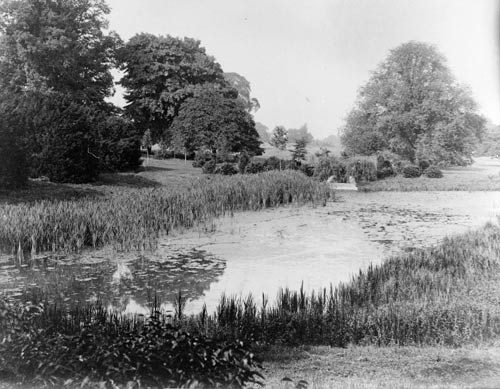
William Cowper's poem about Digby's Walk was published in the 1882 edition of Thomas Wright's A Town of Cowper. p. 187 and reflects his knowledge of Gayhurst: Sweet Digby's Walk, cool shade in summer-time. Leads through an archway to the peaceful Ouse, Where boat and fishing rod supply the taste Of those who seek the meditative charms To memory dear of sylvan river scene. This gives a good description of Digby's Walk from which one can imagine how beautiful it use Cowper's own letters tell us something about the pineapple craze of the period and the new stove George Wrighte built for them, the fact that Wrighte was a keen sportsman, the condition of the turnpike at the time and that park improvements were going on in 1793. At the height of William Cowper's pineapple enthusiasm in 1780 Thomas Pennant was collecting information for his book, The Journey from Chester to London which was published in 1782. His description of Gayhurst was accompanied by an engraving originally drawn by M. Griffiths. It shows a view on the central axis of the house from the south-east, beyond the upper pool. There are no shrubs in the foreground and the reflecting pool is crisply edged with a timber trim. There are standard trees lining the left hand path leading to the Tudor wing and behind the church, and what looks like a palisade fence between the house and the church which could possibly be the stone pillars, said by some to date from the time of Sir Kenelm Digby. The ha-ha had already been built and it can be seen on the bottom right hand side of the picture. The contrast between the flat, smooth grass inside the ha-ha and the more undulating, variable grass of the pasture in the foreground can be seen. There is no indication of a path leading to the village which had already been built at this time, or to the church. This is possibly artist's licence as there must have been one; otherwise the path layout is very similar to the 1881 O.S. and the present day layout, but narrower. There is a slightly inferior copy of this engraving for Walpole's New & Complete British Traveller, published in 1784, which does not reveal any more. Thomas Pennant's description written in 1780 of Gayhurst and the countryside is useful. He describes his arrival in Buckinghamshire: Here the country improves. After passing Stoke Goldington, a small village, a beautiful vale opens on the left, watered by the Ouse, running through rich meadows, and embellished with the spire of Olney church. This river rises near Sysam in Northamptonshire, and, after wandering this country it becomes navigable above Bedford, by means of locks ... About half a mile from its banks, on rising ground on the right, stands Gothurst, antiently Gayhurst; whose venerable form has not been injured by inconsistent alterations... The lands are very finely dressed, and swell into extensive lawns. One before the house consists of a hundred and twenty eight acres; and on the sides are others of great extent. The woods are vast, and cut into walks extensive and pleasing. Several pretty pieces of water, the view of the Ouse and its verdant meadows, and the old respectable house of Tyringham, with its church, on the opposite side, are no small embellishment to the place. This describes the landscape in which Capability Brown played a part but there is very little evidence other than the word of Horace Walpole in his Journal of Visits to Country Seats of Gentlemen, and a brief acknowledgement by Repton. William Praed had not yet engaged John Soane to build him a new house at Tyringham, which was to be c.1796. Repton became involved on both the Tyringham and the Gayhurst estates after 1793. Dorothy Stroud writes about Repton's involvement: Before the end of 1794, Repton was at work on three Buckinghamshire properties - Gayhurst, Tyringham and Hanslope. For the last two there are no details in his publications, but his proposals for Tyringham were obviously conceived in relation to the work at Gayhurst, which it adjoins. Repton arrived on the scene at the time when William Praed of Tyringham was replacing his Elizabethan mansion with a classical house to the designs of John Soane, who later built the elegant single-span bridge to carry a drive across the river Ouse, which flows both through this park and through that part of the Gayhurst estate which adjoins Tyringham, but is cut off from the rest of the former property by the... road. Although Capability Brown had formed a small lake near the house at Gayhurst, Repton was sufficiently impressed by the more distant river to make it accessible from the main part of the grounds. This he achieved by what he called a 'dressed walk which passes under the turnpike road.1 The walk dips steeply as it approaches the road, and then dives under it by way of a three-arched Gothic bridge, buttressed and pinnacled. On the far side, a pathway known as 'Sir Everard Digby's walk' climbs up again, and then leads on to a grove with a stone pedestal within iron railings. A fine stone urn, which should be surmounting this pedestal, is now lying broken at the bottom of the slope. A new urn now replaces the broken one In Humphry Repton's Sketches and Hints on Landscape Gardening published in 1794, he wrote of Gayhurst: The water in the park, though it consists of several pieces of different levels, has the effect of being one single sheet when seen from the house: this was very ingeniously executed by Mr. Brown; but I have also connected the neighboring river and the park, by means of a dressed walk which passes under the turnpike road; and the banks of this river are worthy of every effort to make them a part of the beautiful scenery of the place. An Act of Parliament to turnpike the Newport Pagnell to Stoke Goldington road was passed in 1723. Initially it would have been a poor quality road, subject to flooding next to water meadows. It would have been a long time before improvements were carried out, which would have been done in stages relative to the income from tolls. Improvements could have been made using local materials. Gravel could have been excavated from the Gayhurst quarry, making improvements easier than having to import materials from far away. It is possible therefore, that the creation of the causeway crossing Digby's Walk and Repton's subway could have coincided. This needs further investigation in Turnpike Trust minutes at Northampton Records Office to pinpoint the date. Repton made a contribution to the appreciation of the Ouse valley scenery as seen from Gayhurst land, but assuming "several" to mean two rather than three, it is certainly not possible to see all three sheets of water as "one single sheet when seen from the house". It is possible that the two lower pools might have been seen as one sheet when they were new. Now they are partly obscured by sycamores and alders. The lower of the two is particularly vegetated now and the sheet of water very much reduced in area although looking at the photograph in the Rodbourne College prospectus of 1967, the view point perhaps brings out what Brown wanted to see; the house in -relation to the lake. Repton throws a little more light on "the dressed walk which passes under the turnpike" in Observations on the Theory and Practice of Landscape Gardening1803). He describes his approach to traffic conflict in the landscape: It often happens that a walk in a plantation or shrubbery is crossed by a road or drift way; this has been ingeniously obviated (I believe originally by Mr. Brown), by making one pass over the other, and where the situation requires such expense, a subterraneous passage may either be made under the carriage-road, as I have done at Welbeck, at Gayhurst, and at other places. "Digbys Tunnel"
From this description it appears that the causeway was in place before he created the tunnel, which means that Digby's Walk would have stopped at the road at that time. Although there is no evidence to show that Repton had a hand in the ha-ha at Gayhurst, the engraving of 1780 in “The Journey from Chester to London” shows the ha-ha already there, and we know that Brown undertook some work there, probably between 1749 and 1763. Nevertheless Repton's description in “Observations” of a ha-ha could almost be taken for the one at Gayhurst, but it is different in one important respect. Repton wrote: In the course of this work I may have frequent occasion to mention the necessity of providing a fence near the house, to separate the dressed lawn from the park or feeding ground: various ingenious devices have been contrived to reconcile, with neatness and comfort, the practice introduced by Mr. Brown's followers, of setting a house in a grass field. The sunk fence, or ha! ha! in some places, answers the purpose, in others a light fence of iron or wire, or even a wooden rail has been used with good effect, if not too high; but generally near all fences the cattle make a dirty path, which, immediately in view of the windows, is unsightly; and where the fence is higher than the eye, as it must be against deer, the landscape seen through its bars becomes intolerable. After various attempts to remedy these defects by any expedient that might appear natural, I have at length boldly had to recourse to artificial management, by raising the ground near the house about three feet, and by supporting it with a wall of the same materials as the house. In addition to this, an iron rail on the top only three feet high, becomes a sufficient fence, and forms a sort of terrace in front of the house, making an avowed separation between grass kept by the scythe and the park fed by deer or other cattle, while at a little distance it forms a base line or deep plinth, which gives height and consequence to the house.. The Gayhurst ha-ha and Repton's recommendations differ, as the ha-ha has been excavated and the ground level is the same on both sides but the wall is the same stone as the house. There is a low iron rail on the top Repton wanted to influence the appreciation of the unified river landscape as well as improve the access to it. By creating the dressed walk, he led people from the house, down Digby's Walk, under the turnpike, past the chalybeate spring and on to the Bath House where the landscape opened up to reveal the parkland of Tyringham and an expanded shallow valley; a form of created, 'borrowed' landscape. He wanted to merge the two estates across the river and had attempted to do so elsewhere. At Panshanger and Tewin Water he planned to landscape the whole of the Mimram Valley. There are no illustrations of Repton's work to show what he did in any detail, although he quotes the Red Books for Gayhurst and Tyringham in Sketches and Hints. There is an illustration, though not very informative, based on an original of Repton's in Peacock's Polite Repository, at the Bodleian Library, a kind of diary for the gentry, sponsored by subscription, which served to advertise the work of Repton and others to possible future clients. The page for November 1793 shows Gayhurst from the familiar south-east viewpoint beyond the pool. It is taken from a more distant, elevated position than the illustration in The Journey from Chester to London: the ha-ha and the pool are not visible, more vegetation is shown associated with the church and the pool, and most particularly there is no wide vista leading out behind the house towards the north-west. As it is another axial view, the avenue would have been visible from this higher viewpoint, which suggests that the wide double elm avenue, subsequently destroyed by Dutch elm disease, was not there in 1793 but, woodland came much closer to the house then. This theory could only be correct if Repton's sketch is accurate and his aversion to avenues did not influence his interpretation of the landscape the lack of an avenue is verified in the 1850 plan. In the 1885 photograph the avenue can by seen clearly, as a swathe cut in the woodland, and as a vista from the centre of the house. Lord Carrington's architect, William Burges, made alterations to the garden although there is not a great deal of information about them. The English Heritage Grade II* citation states that "part of the garden layout of 1860 designed by Surges in formal Elizabethan style. Square pedestals with carved upper sections, 5 on S.E. side of house towards the church and 5 on N.W. side." It is possible that Burges also’ laid out the double elm avenue and vista stretching into Gayhurst wood, the two symmetrical quincunxes of trees (in quadrate form) either side of the avenue vista, and designed the yew arches defining the boundary between the garden and the yews of the churchyard, and the layout for the box hedging of the Dutch Garden which is in a mixture of green and golden box. Certainly the square pedestals do not look old enough to date from Kenelm Digby's day although some descriptions say this is so. It is possible that in Surges' day there were ancient pedestals which were copied to introduce into his new design. However, it appears that the original design has been modified; Lady Carlile has pointed out that the pedestals have been raised on plinths and the joints can be seen. In 1882-1883, shortly after the next owner James William Carlile moved into Gayhurst, he completely overhauled the services of the house and restored the church. To commemorate completion of the works he had an illuminated manuscript made. It records the detail of the work which included several garden repairs and other improvements to the estate. New iron gates were fixed to the stable entrance and: The Back Garden
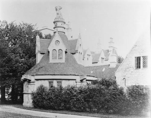
The Three Ponds re-arranged with proper outlets and sluice valves, the centre pond cleaned out and new wall with inlet culvert erected, a new culvert to carry off water from the lower pond, formed and carried under main road. New Stone Entrance Lodge built and fitted complete, and the entrance gates and railings re-arranged. The Lodge now part of the Sir Francis Drake pub, was created by removing the fishing house from the rear of the river-side Bath House. The inscription to commemorate the construction of the new lodge shows the initials and dates of George Wrighte.1751, and James William Carlile, 1882. The Bath House itself was also thoroughly repaired and renovated, and an enclosed court was formed at the back in place of a fishing house. A new dressed stone boundary wall was built on the main road, which can still be seen. Digby's Arch was thoroughly repaired and the Monument over the chalybeate spring repaired, re-erected and fenced in. A new boathouse was erected and new moveable game-keeper's and bathing houses supplied. Several cottages at Gayhurst and Stoke Goldington were repaired and painted, and six farmhouses were completely overhauled. The Lodge
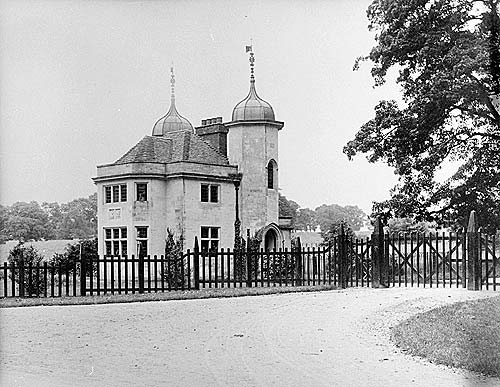
The manuscript ends with the note "The Stone used was quarried, and all the Sand and Gravel was dug on the Estate". There are several gravel pits shown on the 1881 O.S. Map. Thomas Wright gives us a first hand account of some of the landscape features he saw when he visited James William Carlile in June 1885 on his recently renovated estate. "Beautiful exceedingly" are the surroundings of the handsome and stately old mansion of Gayhurst, or Gotehurst; for by the latter name in times gone by it was more usual to call it. The church, half hidden by its firs and yews, stands picturesquely at a short distance from the left wing; the park offers its fine old trees and sparkling sheets of water; and the gardens are ever pleasing with their terraces of smooth-shaven grass, grey stonework, alleys of evergreen, and immemorial yews. On the east of the park a carriage-drive winds to the Northampton and Newport Pagnell road, and ends at a lodge of curious Tudor structure; and on the west Digby's Walk, overshadowed by yews, has for 300 years formed a shady retreat... . The high road itself, arched with the foliage of magnificent beeches, is accompanied on both sides with so many delights that one but instinctively feels that to scenes such as these Gayhurst is indebted for its name. GAYHURST HOUSE
Thomas Wright goes on to describe the first and second George Wrighte's improvements to the park between 1711 and 1738 which give us more insight into what he saw in 1885: Besides his additions to the mansion, Wrighte effected great improvement in the park, but in order to a proper understanding of his alterations we must consult a curious old map (date 1711) still hanging at Gayhurst, which represents the estate as it was when he bought it. In front of the mansion we notice the massive gateway before mentioned, whilst here and there are clotted the cottages of the village. The position of the two rows of yews at the south wing is shown, as is also, though by straight lines, Digby's Walk; and opposite the church we notice the ancient parsonage. Wrighte pulled down the parsonage, the old gateway, and the cottages, or mere hovels as they appear to have been at that time, and in 1738 built the present picturesque cottages near the lodge. Having toured the house, they went into the garden; "...towards the gentle eminence called Digby's Mound..." This mound is unidentified, there is no raised ground in the garden, but it might be the double curved mound shown on the 1980 plan half way down the elm avenue vista. They continued: ...along the terraces, and under the great and noble trees. ...Thence we proceeded past the north wing to the Dutch garden. A weather-stained sundial next attracted our attention, bearing the motto 'Nul que une,' the arms of Digby, the date 1670, and the inscription 'Walter Hayes at the Cross Daggers in Moorefield’s Londini fecit.' Of the labyrinth or maze that formerly existed between the house and the church nothing now remains, nor is this to be wondered at, for garden mazes, unless constantly attended to, quickly fall into disrepair, and in consequence many famous ones have been cleared away: its site, however, is indicated by the different colouring of the grass. Wright's observations are borne out by the fact that there is no visible trace of The maze in the 1885 photograph taken from the roof, showing the parterre Thomas Wright describes a monument to a peacock, which is no longer there, outside the Queen Anne (north-west) front, and then describes the river side scene In the beautiful pleasure-ground by the river is a small building called the Bath-house, and adjacent to it stood until recently, though in decay, a tasteful pleasure-house that was used by the Wrightes for picnics and afternoon tea ...it was removed by the present owner, who placed it as a lodge...at the commencement of the drive leading to the mansion, and it now bears the initials cut in stone, 'G.W. 1751, J.W.C. 1882'. In another part of this pleasaunce an um on a pedestal, (date 1751) stands over a Chalybeate spring, which flows into a square trough, making it a deep saffron from the sediment that is continually falling Many of these features still exist and can be verified, but of the sundial, the labyrinth, and the peacock monument, there is no sign. Garden archaeology might reveal the site of the labyrinth but there is no obvious trace. What could be Digby's Mound appears about a third of the way down the vista swathe. The date of 1751 on the pedestal of the um rules it out as Repton's creation and suggests Brown as the more likely initiator. Therefore Repton could only have had some involvement with the urn. The chalybeate spring is far from "saffron". It is, as one would expect, a bright rusty orange/brown. Alterations after the Carliles. During World War II the house was requisitioned. MoD offices nicknamed the " 'ush-'ush buildings" were constructed for the Wrens to do their de-coding, south-west of the stable block, between the ha-ha and the gravel pit. Tragically, the fine finials shown in photograph of 1885, were used for target practice by boisterous US servicemen after a dance and have never been repaired. In the post-war period Gayhurst was twice used as a school, during which time the grass tennis courts went and netted asphalt courts appeared. These are right on the axis and are a disastrous interruption to the long vista. The Cerebus Building (Male Servants Lavatory)
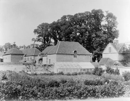
The Cerebus building used to be surrounded by large yews and what was called the 'back1 garden, where roses and cut flowers were grown in beds cut out of lawn. The yews have been felled and replaced by a five foot high beech hedge; this encloses the garden now belonging to an adjacent apartment occupying the Cerebus building . The stable block has been changed into mews cottages, and their gardens occupy various corners of the stable yard. Some of the cobbled surface finishes have been kept, for example, in the tiny courtyard between the Tudor wing and the Surges kitchen. The walled garden was beautifully kept while the house was occupied as a school but by 1972 it was derelict . Three new mews houses finally transformed the walled garden in the 1980s. Remnants of the orchard, outside the walled garden, can be seen beyond the gardens of the new houses to the south-west. The 'ush-'ush building has been replaced by new stables and the horses graze outside and inside the ha-ha on land to the south-west, north-west and north-east of the house. The Water Garden
The water garden, carefully tended by Sir Walter Carlile's first wife, has become neglected and to a large part, silted up. The small conifers seen in the 1885 photographs have now grown to 60 feet and the small clipped, rounded yews have become substantial trees. A low yew hedge, no higher than 600 mm, allowing views from the house to the open landscape to the south-east, is now kept at just above eye level. The water garden has therefore become quite cut off from the house and the characteristic views of Gayhurst, seen in most of the engravings, and in the 1885 photograph, have been obscured by the dark evergreen foliage of the conifers. It is now quite difficult to get a view of the house from the south-east at close quarters. The ha-ha is in poor repair along much of its length. Its dressed capping can only be seen in a small section on the south-west side. Storms have taken their toll of many of the parkland trees, as has Dutch Elm disease. The double avenue of elm seen in the 1885 photographs has entirely gone leaving a few stragglers of other species. There is a dip in the intermediate horizon of the vista and two crescent shaped banks, presumably made to accommodate some statuary The horizon is now blocked by coniferous woodland, which is a great pity as it advances in the landscape rather than receding. This is a most unfortunate modern intervention, adding to the destruction of the vista and was not there in the 1885 photograph. A massive ancient walnut tree adjacent to the driveway near the lodge, said to be between 200 and 270 years old, has had several branches amputated and is now in the safe keeping of the County Council. The other very large trees are within the ha-ha. A grove of very tall trees planted roughly on a grid, and Including horse chestnut, plane and beech, lies either side of the vista ancould be 150-200 years old. They are tall and straight and have been drawn upwards by their fairly close planting of eight or nine metres. Many of the massive yew trees have been cut back as they were felt to be too close to the newly converted houses and taking too much light. The form of the box parterre, named the 'Dutch garden' by the Carliles, has been kept. The Kenelm Digby sign of the linked circles and squares is clearly discernible as a pattern in the low box hedging but it is very ragged and straggly with spaces where plants are missing. The box 'snails' in memory of Kenelm Digby's edible snails brought from France for his frail wife, are still kept clipped and stand sentry at the comers of the parterre. The arched yew topiary between the parterre and the large church yews has lost its form but the wrought iron frames are still intact The yew hedges round the front lawn are trimmed but kept above eye level obstructing views out to the pool and the hillside. The lodge at the entrance to the park was sold off after the war and an extension which is quite different in character, has been added. It is now the Sir Francis Drake pub, and the main entrance gate has been set back to make space for its car park. Some of the adjacent coppices still have the wrought iron protective fencing around them but, as it disintegrates, it is not replaced. CONCLUSION The Gayhurst estate expanded from 1,000 acres at the time of the Domesday survey, to 3,000 acres in 1265. having added the neighboring parish to Stoke Goldington. The Estate was approaching its largest and its owners their most influential at the end of the Cl6th and beginning of the Cl7th, the period when the Elizabethan and Jacobean phases of the house were built and the estate reached nearly 4,000 acres. No records of the park in this period have come to light in this study. George Wrighte bought only 2,000 acres in 1704. He was secure, with a famous and wealthy father, but with less political influence himself, and no power at court. He and his son and grandson lived as country gentlemen, improving the house, building the church and engaging the services of fashionable landscape designers, first Capability Brown and then Repton. The George Wrighte’s enjoyed the use of the park and the Bath House for recreation. They had spent time and money to improve it. It had beautiful vistas, lakes, walks and parkland, which can be identified as Brown's and Repton's work. When the Wrighte line came to an end and Gayhurst was passed on to the Wyndhams, new innovations appeared to cease until Lord Carrington was granted a 21-year lease on the property which at that time had reached 2500 acres. Lord Carrington was highly influential but was a leaseholder with several other houses. He used Gayhurst mostly for hunting, shooting and fishing. He had a flamboyant lifestyle and wanted something dramatic. By commissioning William Surges he attempted to recreate the medieval and renaissance atmosphere at Gayhurst - a style which suited it. Surges transformed the grounds close to the house with the geometric terrace, parterre, pedestals and yew walks. The three designers added aesthetic value, in their own individual way, with each phase and in today's terms, historic value, which should be conserved. The detail we have available does not permit us to restore the parkland and garden to one period alone and much of the pre-Burges work has been destroyed to make way for the new garaging and mews development. All three designers contributed to the aesthetic quality of the grounds which can be distinguished and separated into parkland, Digby's Walk and the setting for the house but nonetheless are compatible with one another and with the house with its transformed present-day function. It is a landscape where three design periods synthesize and should be restored to make evident and to re-emphasise the work of Brown, Repton and Surges and the rich historic legacy within today's context. |
||||||||||||||||||||||||||||||||||||||||||||||||||||||||||||||||||||||||||||||||||||||||||||||||||||||||||||||||||||||||||||||||||||||||||||||||||||||||
|